The Hanoi Ring Road 4 project is one of the key infrastructure projects in the context that Hanoi is facing serious infrastructure and traffic overload. The large scale and synchronous design make this project a new infrastructure driving force, paving the way for breakthroughs in surrounding areas.
Overview of Ring Road 4 Project
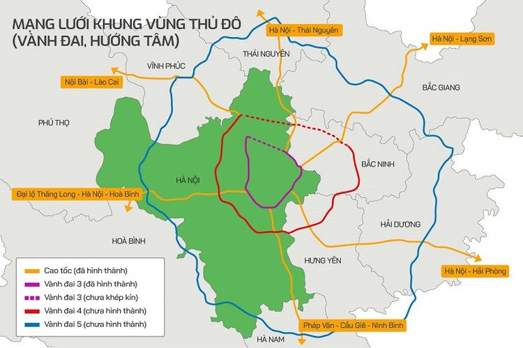
Hanoi Ring Road 4 is one of the national key transport projects, approved by the National Assembly in Resolution No. 56/2022/QH15. The 112.8km long route, with a total investment of VND 85,813 billion, aims to solve traffic congestion in Hanoi while opening up more development space for the entire region and the northern provinces.
Once completed, Ring Road 4 will become an important traffic axis, increasing transport capacity, connecting major economic centers and promoting sustainable growth.
Length and Range
The 112.8 km long Ring Road 4 section not only connects Hanoi with neighboring provinces but also helps to significantly reduce the load on the main roads in the Red River Delta, opening up development opportunities for the whole region. This route will pass through important areas of the Red River Delta, contributing to improving transport capacity and reducing the load on existing traffic routes. The route begins in Thanh Xuan commune (now Noi Bai commune), the old Soc Son district, Hanoi, intersecting with the Noi Bai – Lao Cai expressway. The road then continues through Hung Yen and Bac Ninh provinces, ending in Que Vo district (now Que Vo ward), Bac Ninh province, where it intersects with the Noi Bai – Ha Long expressway. Specifically:
- Hanoi: 58.2km
- Hung Yen: 19.3km
- Bac Ninh: 35.3km
This route will cross major rivers such as the Red River and the Duong River, contributing to improving transport infrastructure, shortening the distance between important economic centers and promoting regional trade.
Scale and Design
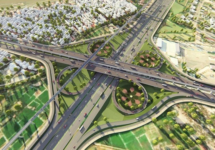
With the aim of meeting high traffic demand, Hanoi Ring Road 4 will be designed according to expressway standards with 6 lanes. The road cross-section is from 90 – 135m, ensuring large traffic and limiting congestion. This is one of the important expressways that helps connect key economic areas in the region.
- Road scale: 6 expressway lanes and parallel road systems on both sides
- Maximum speed: 100 km/h
- Road surface: From 90m to 135m wide, depending on each section
- Road structure: Cement concrete base structure, applying the standards of grade III roads in the plains.
- Urban service roads: Designed to serve traffic in residential areas, minimizing congestion on main roads.
The project is divided into phases and is expected to be completed in 2027, when Ring Road 4 will not only help reduce traffic but also expand development space for the capital and neighboring areas.
Detailed Roadmap of Ring Road 4 Planning
The Ring Road 4 route is 112.8km long, passing through the provinces of Hanoi, Hung Yen, Bac Ninh and Bac Giang, with the role of helping to reduce the load on existing traffic routes, while promoting regional economic development. Let’s learn about the planning route and planning map of Ring Road 4 Hanoi.
Hanoi
The Ring Road 4 route passing through Hanoi City is about 56.5km long, accounting for nearly half of the entire route. This section of the route plays an important role in connecting the capital with neighboring provinces, promoting trade and facilitating regional economic development.
- Route length: ~56.5km
- Starting point: Km3+695 Noi Bai – Lao Cai Expressway, Thanh Xuan Commune, the old Soc Son (now part of Noi Bai Commune).
- Ending point: National Highway 2 intersection in Van Khe Commune, the old Me Linh (now part of Me Linh Commune).
This route continues through communes such as Hong Ha, Dan Phuong, Duc Thuong (former Hoai Duc district) and crosses Thang Long Avenue, connecting with National Highway 6 in Yen Nghia ward (former Ha Dong district). The route then continues through National Highway 1A, crosses the Red River through Me So and finally enters the former Khoai Chau district (now the communes of Khoai Chau, Trieu Viet Vuong, Viet Tien, Chi Minh, Chau Ninh), Hung Yen province.
With this new route, suburban areas will be quickly connected to the main gateways of the capital, reducing traffic congestion and creating opportunities for trade development between Hanoi and the northern provinces.
Hung Yen
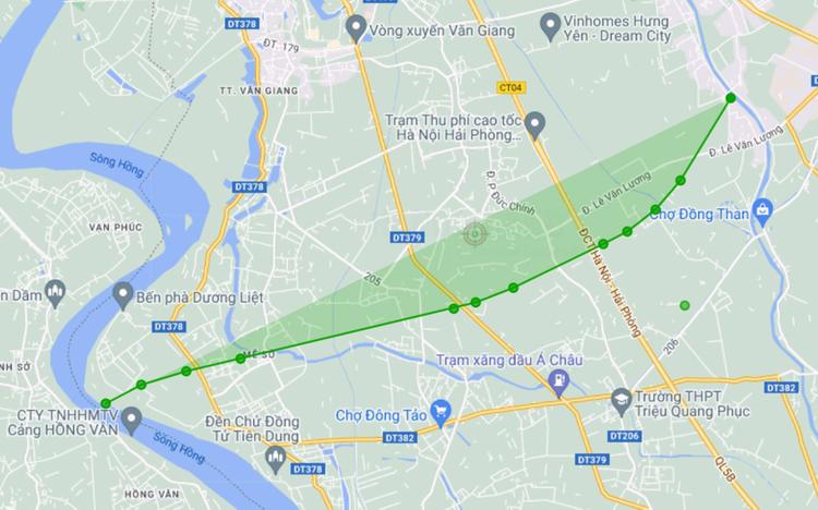
The section of Ring Road 4 passing through Hung Yen province has a total length of 20.3 km, starting from Khoai Chau district (now the communes of Khoai Chau, Trieu Viet Vuong, Viet Tien, Chi Minh, Chau Ninh) and passing through Yen My district (now the communes of Yen My, Viet Yen, Hoan Long, Nguyen Van Linh); Van Lam (now the communes of Nhu Quynh, Dai Dong, Lac Dao) and Van Giang (now the communes of Van Giang, Me So, Phung Cong, Xuan Quan). This route connects directly to National Highway 5 at km17+900, near the Hanoi – Hai Phong toll station, before crossing the Hanoi – Hai Phong railway line and continuing to the old Nguyet Duc commune (now Ninh Xa ward), Bac Ninh province.
- Route length: ~20.3 km
- Starting point: Intersection with National Highway 5
- Ending point: Intersection with National Highway 39A in Van Lam district (old)
- Intersection: Intersection with the Hanoi – Hai Phong railway line
The route not only helps to improve traffic congestion but also opens up opportunities to connect new industrial parks and urban areas in Hung Yen with neighboring areas. This will promote investment and economic growth, while improving the quality of life for local residents.
Bac Ninh
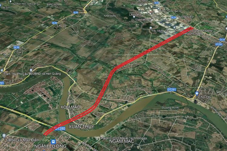
- Route length: ~21.2km
- Starting point: Nguyet Duc commune (now Ninh Xa ward), Thuan Thanh district (old), intersecting with National Highway 38 at Tram Lo commune.
- Ending point: Nam Son commune (now Nam Son ward), Bac Ninh city, intersecting with Noi Bai – Ha Long expressway.
Bac Giang (Now Bac Ninh)
The Hanoi – Bac Giang Ring Road 4 has a total length of 20.8 km, including one main route and three branches, playing an important role in connecting areas of Bac Giang with Hanoi. The route will facilitate trade and promote economic development in areas along the route.
- Route length: 20.8 km
- Starting point: Coinciding with National Highway 1 at km 129+200, Nenh town (after merging to become Nenh ward), former Viet Yen district.
- Ending point: Xuan Cam – Bac Phu Bridge, Bac Phu Commune (now Da Phuc Commune), Soc Son District (now Soc Son, Da Phuc, Noi Bai, Trung Gia, Kim Anh Communes, Hanoi.
- Important projects:
– Railway at km 1+110.925 (former Viet Yen District, now Viet Yen, Nenh, Tu Lan, Van Ha Wards)
– Xuan Cam – Bac Phu Bridge crosses Cau River at km 20+658, bordering Hiep Hoa District (now Hop Thinh, Hiep Hoa, Hoang Van, Xuan Cam Communes) and Soc Son (formerly).
According to the plan, this route is built according to grade III road standards, with the goal of promoting traffic connectivity and improving infrastructure quality. Currently, about 2/3 of the route length has been completed and is expected to be open to traffic by the end of this year, connecting Bac Giang with Hanoi, creating momentum for regional economic development.
Update on the Progress of Ring Road 4 as of August 2025
The overall picture of the Ring Road 4 – Capital Region project shows a “hot” construction site spanning many points, but still stuck in site clearance bottlenecks (especially residential land). This is the main reason why the overall pace is slower than the initial plan, creating the risk of missing the completion deadline by the end of 2025. Below are detailed updates by location from official electronic newspapers.
Hanoi: Focusing on Parallel Road 2025
In the capital, progress is being “accelerated” with two clear goals: completing parallel roads (urban roads) in 2025 and the expressway section in 2027. The land clearance rate has approached the absolute threshold, but there are still a few “bottlenecks” of residential land that need to be resolved.
- Land clearance: nearly 99%, 13/13 resettlement areas have been completed; about 18 remaining locations (concentrated in Me Linh, Hoai Duc, Yen Nghia, Binh Minh).
- Construction of parallel roads: embankment volume ~85%, crushed stone ~35%; many bridges and culverts are under construction simultaneously; some sections of Me Linh – Dan Phuong – Hoai Duc have been partially paved with asphalt concrete.
- Construction of expressway sections: construction of expressway overpass started on May 19; Target completion in 2027.
Upcoming focus: Handling land issues and synchronizing construction materials to ensure urban road progress in 2025.
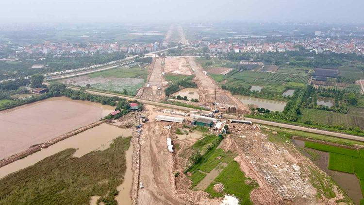
Hung Yen: Parallel Road Reaches 70% of Volume
Hung Yen is accelerating progress with the approach of parallel infrastructure first, expressway later. Hung Yen has completed site clearance and continues to accelerate construction with many large packages.
- Site clearance: 215/225.9 ha (accounting for 95.1%) have been reclaimed and handed over.
- Resettlement areas: 7/7 cemetery renovation areas, 10/11 resettlement areas have been completed.
- Construction: parallel road has reached ~70% of volume; some sections have been paved, other sections have been leveled, and drainage installed.
- Implementation milestone: the project will start construction on the entire route on June 25, 2023; the section through Hung Yen will start construction on November 22, 2023.
- Completion milestone: Expected to be basically completed in 2026, the entire route will be open to traffic in 2027.
Bright spot: compensation and support policies are thoroughly implemented, creating consensus and reducing social friction, helping the construction site keep pace.
Bac Ninh: Urban Road Sprint Before December 31, 2025
Bac Ninh maintains a good pace in site clearance and construction organization, but faces challenges in material sources (sand, fill soil) due to lack of on-site mines, requiring inter-provincial coordination to compensate.
- Progress target: basically completed by 2025, complete around April 2026 (master plan estimated 2026–2027).
- Land clearance: 97.2% of site area completed; the remaining 2.8% is expected to be completed by the end of November 2024.
- Parallel road: Launching a 455-day construction emulation movement, with the goal of completion before December 31, 2025.
- Difficulties: lack of sand, fill soil; the solution is to link supply sources from neighboring localities.
Expressway section: after urban roads, continue to deploy a complete 6-lane expressway, designed speed of 100 km/h; the expressway section through Bac Ninh is chaired by the Hanoi People’s Committee. Ring Road 4 – Capital Region opens up a “golden corridor” connecting many industrial parks such as Thuan Thanh 1-2, Gia Binh, Nam Son – Hap Linh, creating momentum for the goal of turning Bac Ninh into a centrally-governed city in the period 2021-2030.
Bac Giang (Now Belonging to Bac Ninh): Continues to Complete Projects Ahead of Schedule
The Hanoi – Bac Giang Ring Road 4 has been open to traffic since April 30, 2020, with the signage system – basic infrastructure completed since the end of 2020. Currently, the locality is focusing on adding items of overpasses for people, solving intersections with risk of congestion.
- Bridges – main works: The project has 3 large bridges, of which the overpass for people crosses the Hanoi – Bac Giang highway connecting Quang Chau Industrial Park (Viet Yen); the bridge for people in Van Trung ward is expected to be completed in 2025, helping to reduce congestion during rush hours.
- Regional connectivity goal: ensure safe movement of workers – goods, shorten travel time between production poles.
Impact Assessment of Ring Road 4
Ring Road 4 is not only a new transport route but also a “space-creating infrastructure” for the entire Capital Region to expand population density away from the core of Hanoi, open inter-regional connecting axes and activate the satellite urban-industrial chain.
Socio-Economic Impact
For Vietnam, roads are the “backbone” of freight transport: in 2016, 77% of freight volume was transported by road according to the World Bank’s report on Vietnam’s truck industry. When the beltway is completed and passes through production and consumption gateways, transportation costs will decrease thanks to optimal distances and fewer congestion points.
Regarding development space, the National Assembly Resolution clearly states the goal of creating new growth space for Hanoi and the provinces in the region, instead of just solving congestion. This means: industrial parks, warehouses, wharves and new urban areas have more conditions to stay close to intersections, thanks to quick connections to seaports, airports, and vertical and horizontal highways.
Field experience shows that the route corridor passes through many large industrial parks, such as Nam Son – Hap Linh in Bac Ninh, which has the advantage of connecting directly to Hanoi, Noi Bai and the northern seaports. When the beltway is operational, this regional supply chain will be more convenient for both inputs and outputs.
Impact on the Real Estate Market
Even during the construction phase, land prices around the route have increased sharply in some areas. Kinh te & Do thi newspaper recorded an “investment wave” around Ring Road 4, with an unusual price increase and advised investors to be cautious due to speculative risks.
Batdongsan.com.vn’s online data also reflects an increase in searches and transactions at the end of 2024; some areas such as Me Linh recorded an increase in asking prices compared to half a year ago. Changes in land prices show rapid growth due to infrastructure progress, but not all areas along the route have sustainable increases.
In addition to market sentiment, land price frameworks also affect cost calculation and expectations. Decision 71/2024/QD-UBND of Hanoi (effective from December 20, 2024) adjusts the land price list, which serves as the basis for many financial obligations related to land and planning. This is an important legal basis when assessing the value and risks of land plots along Ring Road 4, especially in areas with resettlement, land use change and land recovery.
